

Location & Description
Budhi camp site was in Bundi village located at an altitude of 2740 meter in Pithoragarh district of Uttarakhand.
It is a small village with a population of anout 665 living in 215 houses.
Dharchula is nearest town to Bundi which is approximately 60km away.
During winter months, villages located in the upper regions of the Kailash Manas Sarovar Yatra route remain covered with snow. The villagers of Budhi and other areas usually have their winter residences at warmer places like Dharchula, Jauljibi, Didihat and Thal.
Generally in the month of October, the villagers pack the doors of their houses with polythene and move to their winter residences along with their cattle. These people temporarily do small jobs during their stay in their winter residences. Since these people come every year, the work is easily found. In April, these people again go to their residences at upper areas.
Children of these villages study for six months in the mountains primary school and six months in Dharchula. Weather address is given for weddings. Voting has been facilitated in the upper or lower regions according to the weather
The migration of these people also increases the population of the four towns of Dharchula, Jauljibi, Didihat and Thal and business at these towns also increase by 10-15%.
On May 8, 2020, a strategically crucial road at a height of 17,000 feet, from Ghatiabagar in Uttarakhand to the Lipulekh pass was inaugurated by Defence Minister Rajnath Singh. This road is expected to help pilgrims visiting Kailash Mansarovar.
However, this road will take more time to be fully opened for traffic as two bridges with lengths of 150 feet and 100 feet are being constructed between Malpa and Budhi. It has been reported that most of the work of widening the road is to be done in the 10 km portion between Malpa and Bundi camps of the road. This area is full of narrow bends where retaining walls are to be installed to make the road resistant to landslides.
Border Roads Organisation (BRO) engineers are completing this herculean task of making road connectivity possible on such a rugged terrain cutting straight rocks on the left and right side of river Kali.
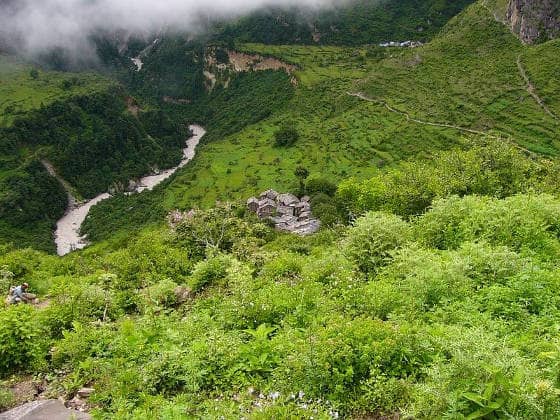
Aerial view of Bundi (Budhi)
References
Uttarakhand village information on Bundi (Budhi)
India TV new report on inauguration of Kailash Mansarovar road
Compiled by Ms. Bani Baral, author of "Kailash Manas Sarovar Yatra, looking back – Day 7 Journey from Malpa to Budhi"
Map location is approximate